Hello guys today we are talking about What is AutoCAD Civil 3D, Learn free AutoCAD & Sketchup only at www.autocadprojects.com
Do you know what is AutoCAD Civil 3D?
AutoCAD Civil 3D software looks like AutoCAD. If you are an AutoCAD user, then it will be easy to learn this software for you.
We can say that AutoCAD Civil 3D is an extension of AutoCAD and it is a very useful extension.
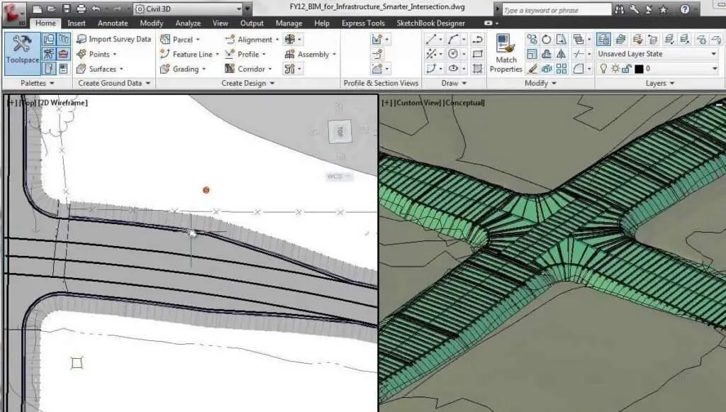
This software is a design solution for civil engineers that supports building information modeling (BIM) workflows with integrated features to improve drafting, design, and construction documentation.
By using this software, we can improve project performance, maintain consistent data, and follow standard processes.
Uses of AutoCAD Civil 3D
- Building Information Model (BIM) [three-dimensional] can be created by using AutoCAD Civil 3D.
- This software increases productivity and quality by saving time.
- This software enables us to create two-dimensional (2D) cross-sections and we can add them to 3d models easily.
- In this software, we can also create cross-sections more quickly by using the new layer management tool.
- Drafting and documentation are made much easier by this software.
- We can do surface modeling, corridor design, geotechnical design, storm design, etc. by using this software.
Features of AutoCAD Civil 360
Surfaces
3D elements are generally made of triangles that represent a particular surface.
The use of these elements creates a surface from a topographical plan to represent the existing ground.
Alignments
Alignments are 2D horizontal elements that are a composition of straights, curves, and transitions.
Profiles
Profiles attach to specific alignments and contain vertical data regarding the elevations.
Start with a baseline profile generated from the existing ground surface.
You can create a design profile for your road, and design manuals for roads and bridges.
Corridors
- Civil 3D combines the alignments, vertical profiles, and assemblies to create corridors.
- These are 3D elements that include surfaces and volumes.
- They can create existing ground surfaces to create earthwork footprints.
- Corridors represent, in essence, the proposed linear infrastructure. also, read our other articles.
- Learn free Autocad Here. A-Z knowledge of AutoCAD and Sketchup and contact us for making 3D models and 2D Drawings.
Thank you for reading.
Know more About AutoCAD on Youtube
You can Read our Other Articles
- What is AutoCAD Electrical? (99% want to Know) March 2025

- AutoCAD Student Teacher Watermark (99% A-Z Tips) March 2025
- AutoCAD Earth Ground Symbols (70% Don’t Know) March 2025
- What Computer language was AutoCAD written in? (90% Don’t Know)
- Best 11 laptops for AutoCAD 2025 (100% You Like) March 2025

- Autodesk Takeoff 2025 | 80% of People Don’t Know (March 2025)

- AutoCAD Section Line | 100% You Don’t Know March 2025
- AutoCAD shortcut keys (80% New keys don’t Miss) March 2025
- AutoCAD 2025 software price in India (99% it’s Confusing) March 2025
- How does Autodesk clear temp files? (100% Legit Tips) March 2025


Leave a Reply